 |
| Cyril, OK |
We spent the night in Ardmore, OK, as we knew we would be in excellent position for today's chase. Upon waking up in the very run down Days Inn, we sensed that today was going to be very special. I woke up around 8:00 that morning, and the dew points were already in the 70s. During the weather briefing, CAPE values were progged to be in excess of 4500 J/kg, which means an incredibly unstable atmosphere. Temperatures were predicted to be in the mid 90s, which would be more than enough to break any cap the atmosphere would have. Finally, lift would not be a problem, as we were targeting what is known as the "triple point", which is the point where the dryline, warm front, and cold front meet. This is often the hotspot for severe activity. Unfortunately, we were concerned that the cap may not be strong enough to hold in all the necessary ingredients, so early initiation was not out of the question.
 |
Chris Gullickson by the van, with guests
scattered throughout the park |
After the briefing, we heading into downtown Ardmore for a late breakfast/early lunch at a place called The Hamburger Inn. We took our time, because we were already in good position. Once we finished, we drove for about 2 hours to the west to a town called Waurika, OK, where we found a convenience store. One of our guests sat on a bench, and there was a black widow spider underneath it. In my experience as a chaser, I have had very good luck on days that I see a poisonous creature. For example, on the day of the Goshen County tornado in 2009, we came across a rattlesnake. Anyway, we eventually made our way to Cyril, OK, where we found a park to relax for a bit. We also figured this would be a good time to get a group picture. Even at this point, nothing was starting to go up, which meant the cap was still holding its own.
 |
Waiting for initiation
near Minco, OK |
We continued north into Central Oklahoma, where CAPE values were near 5500 J/kg. This was absolutely phenomenal, as any storm that could break through the cap here would become a beast. There were some Cu that were trying to do something, but they sputtered. After making what would be our final pit stop for the day in Minco, OK, we headed a few miles west to look for a nice open area to observe the now towering Cu. There were some decent looking cells to the west, but we did not want to go after a sucker storm and miss the big show later. At last, there was an even better cell that just developed, and it looked promising, so we drove in that direction.
 |
| Wall cloud |
As we continued west, those little cells from about 15 minutes ago were now explosive updrafts. This is what we were waiting for!!! Large hail was also falling from these storms, so it was amazing how fast this all transpired. In a case like this, targeting the southern-most storm would be our best option. It had a nice rain-free base, which is where a wall cloud would form. We were about 9 miles east of this storm, and it was moving right for us, so we played the waiting game. Little did we know how much our patience would pay off.
 |
| Scraggly wall cloud |
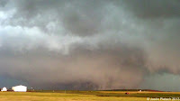
At this point, the cloud tops were at least 60,000 feet, which does not happen a whole lot. We had a nice vantage point of a scraggly wall cloud, so we were in good shape to watch a tornado, if one was going to form. As we were taking pictures, we were getting hail and moderate rain, so we repositioned ourselves to the SE of the storm. After heading east for about 5 miles, we found a very good N-S paved road, and the terrain was very flat and had no trees. Basically, this was a chaser's dream landscape, as it would provide an amazing view of the storm. We stopped about 3 miles west of the El Reno airport, and we noticed the supercell was becoming an HP monster. This was not good, as if a tornado did form, it would be hidden in that dark curtain of nastiness. There was a storm base to our NW that had an earlier tornado report, and that storm base was now starting to act weird. Around 5:54 PM, it appeared that a funnel cloud was trying to develop, and rotation was becoming more evident.
 |
| 6:03:19 PM |
 |
| 6:03:26 PM |
 |
| 6:03:45 PM |
 |
| 6:05:18 PM |
 |
| 6:06:00 PM |
 |
| 6:04:37 PM |
This is an excerpt from Bill Reid's blog of that day.
"By 6:00 p.m., the nearby storm base on the leading edge of this supercell was changing fast. VERY FAST. VERY VERY VERY VERY FAST!!! There is some lowering of the base and some noticeable rotation now. Is this a tornado hand-off? Is this a new meso that is quickly cycling up? Is this west wind that is getting stronger here an RFD wind? The answers are all YES —- in a matter of two or three minutes, we were suddenly looking at a tremendous and large low-level circulation, just a mile or two to our north-northwest! This thing formed crazy fast, and it didn’t tease us long before going tornadic. Big fat funnels and big skinny funnels went up and down and appeared and disappeared beneath this merry-go-round wall cloud. It was mesmerizing. It was close! I held the 5D as steadily as I could as it rolled in HD video mode. The scene was surreal. Above the green, grassy countryside these gray/white tornadoes were dancing around beneath the whitish wall cloud, and then around and below this tremendous “mother” funnel cloud. It was multi-vortex city. Rain and wind was hitting us hard from the west now. Were there any other issues? Yes. The mother funnel cloud was coming right at us. UGH."
 |
| 6:06:40 PM |
 |
| 6:06:43 PM |
Basically, we were right in the path of the tornado-cyclone, and we had to get out of there fast!!! All of a sudden, we were caught in incredibly powerful winds, and we were in the circulation. We could only go 55 mph, as the roads were made of gravel. The tornado was speeding along at 45 mph, so there was absolutely no room for error. Until we were able to get on a paved road, we were at the mercy of the storm. We were all fortunate to get out alive after our very close brush with death. Meanwhile, the tornado grew to an astonishing 2.6 miles wide, and wind speeds were estimated at 295 mph. The size alone made this a record breaker, so it was pretty neat!! Unfortunately, the weather community lost 3 well respected chasers on this day.
 |
| This was the tornado at its peak intensity |
 |
| 6:27:10 PM |
As my group made our way into Oklahoma City for the night, we saw just how destructive these storms were. Eventually, storms started training along the same path, and OKC saw about 8 inches of rain that night. The damage was unbelievable, and we were lucky to find a hotel that still had power and very little damage, even though the hotel itself was a dump. When I woke up the next morning, I realized that what had happened was not a dream. It was a very sobering reminder that storm chasing is very dangerous activity, and even the best chasers out there will find themselves in dangerous situations. We were incredibly lucky to escape with no damage to our equipment or guests and even happier we got out alive. The experience exponentially increased my respect for the weather.
For those who are interested, you can visit Bill Reid's Stormbruiser blog at this link.


