


 Our starting point was in Glendive, MT, and we needed to head west about 3-4 hours. Lewistown, MT, was our intended target, so we ate lunch at Harry's Place when we arrived. They were very happy to accommodate our large group, and they were quite friendly. We lounged on their outdoor patio area after lunch and decided to head west out of town to monitor any potential storm development. There was a rest/camp area about a mile out of town, so we lingered there for a while. Patience would be key today, because the road network was very sparse. If we got suckered on an early storm, our chances of being in position for a play later in the day would go down the drain. There were a couple storms to our north, but chasing them would not be possible due to the aforementioned road network. While we were waiting, we decided to stop at a convenience store for ice cream, and that seemed to do the trick. A very nice storm went up, and we were able to intercept it near Moccasin, MT. As we were following it to east of Roy, MT, it gave us multiple wall clouds and came close to producing a tornado. It was difficult at times to see the base, because there were lots of hills in this area. When that storm began turning into an outflow producer, we latched onto another one that had awesome structure. We stopped along the road to watch the storm approach us, and the shelf cloud was very picturesque. As we were taking pictures, outflow from other storms came through and drastically reduced the air temperature. We followed the storm into Roy, MT and stopped near what appeared to be an abandoned fueling station. A few of the guests needed an emergency pit stop, and tree cover would be the perfect place to do it. After milling about and watching the storm, we herded the guests back into the vans and got blasted with wet RFD winds as we were leaving. Along the way, the tour guide noticed a circulation in a field next to us, so we were wondering if that was a weak tornado. After we emerged from the RFD winds, reports started coming in of a rain-wrapped tornado very close to the area we were in. Damage reports also began coming through, so we returned to the scene of the crime. Golf ball sized hail was also present, and we noticed some damage to the buildings. One of the walls was bent outward, and multiple branches were snapped. In addition, a signpost was snapped at the base. After poking around, we decided to start our drive to Billings, where our motel was. Total mileage for the day was 525 miles.
 |
| Moccasin, MT |
 |
| Fortuna, ND |
 |
| US/Canada border |
 |
| Circle, MT |

 |
| Mothership approaching |
 |
| Ardmore, SD |
 |
| Need a car? Go to Ghost Town Ed's Used Car Lot in Ardmore, SD! |
 |
| Pretty storm east of Weyburn, SK |
 On June 7, our plan was quite simple. We needed to head north towards Saskatchewan in order to be in great position for June 9, which was progged to be a great severe weather day. This death ridge has been causing a lot of headaches, because severe weather cannot develop and stay sustained in this type of pattern. We got rooms in Spearfish, SD, and we stopped along the way in Ardmore, SD, which is a ghost town. There were many old cars to be photographed, and the old buildings added a certain charm to the unincorporated community. After we spent about 25 minutes poking around, we continued our journey to Spearfish and found a small storm to photograph along the way. We drove 405 miles today.
 |
| Crepescular rays |

 Today began a new tour, and we rounded up the group at 10 a.m. for the orientation and weather briefing. We left the base hotel after 11, and we ate lunch about a mile away. Storms were predicted to go up near the Denver area later in the day, so we did not want to venture too far away. On the other hand, we knew we would be chasing in Canada on Wednesday, so we also wanted to work our way north. That being said, we noticed some perky cumulus clouds north and east of the Denver metro area, and they were near the Palmer Divide. We drove towards the Cu field and noticed some were trying very hard to become thunderstorms. As we headed into Greeley, CO, we latched onto one that was looking good both visibly and on radar. We took a pit stop in Ft. Collins, CO, and the other van decided its alarm was going to malfunction. The sirens, sounds, and flashing lights inadvertently caused people to pull over with confused looks on their faces. We continued the chase for a bit until we came into Greeley, CO and stopped at an auto store to replace the batteries to the key fobs. That did not work, so we found a Chevy dealership in town (our vans are from Chevrolet). The mechanic could not pinpoint the problem, so he cut the wire to the sound, leaving only the flashing lights. Now, the van's lights flash if it goes over a bump, shuts down, starts up, or a fly sneezes on it. Anyway, there was a beefy looking cell north of the Denver metro area, and it was moving south at 20 mph. We knew we could easily catch it, but this storm was dropping 2.5" hailstones. Luckily, we just ran into small hail and torrential rain. Even though the storm's shape looked good on radar, it eventually became outflow-dominant. After staying with the cell near Watkins, CO, we called it a night and headed to Greeley after driving 304 miles.
 |
| Pretty flower |
 |
| Wichita Mountains Wildlife Nature Preserve |
 |
| Bison |
 |
| Twistex Memorial |

 |
| Small tarantula |
 |
| Male peacock |
 |
| Female peacock |
 |
| Caverns of Sonora |
 |
| Caverns of Sonora |
 |
| Shear funnel |
 |
| New wall cloud |
 |
| Hail shaft |
 |
| Storm trying to cycle up after getting hit with outflow |
 |
| Alpine, TX |
 |
| Cactus |
 |
| Marfa, TX |
 |
| Near Alpine, TX |
 |
| Marfa, TX |
 |
| The Hudson Hornet in Marathon, TX |
 |
| Neat truck |
 |
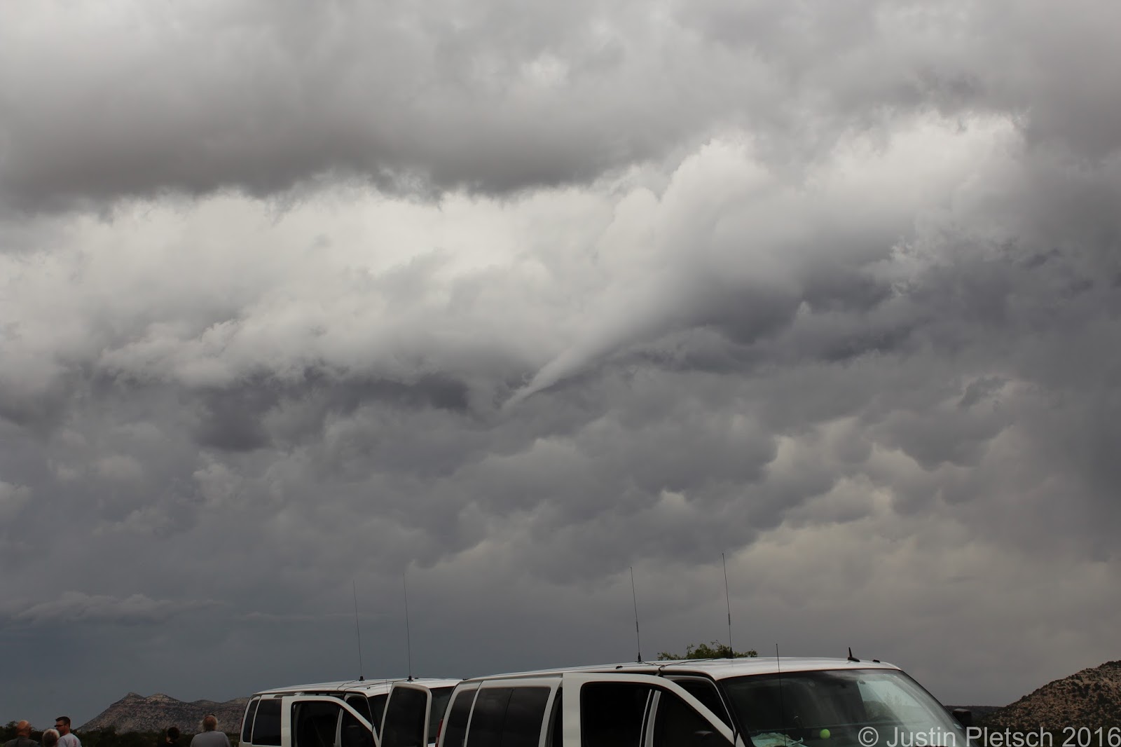
| Funnel east of Alpine, TX |
 |
| Wall cloud south of Marathon, TX |