Saturday, July 22, 2017

July 6 reposition day/Mt. Rushmore

We began the day in Steele, ND, and the only good area for severe weather was in central WI.  This posed a problem for two reasons.  First, that area is known for its hills and trees, which means poor terrain for chasing. Second, we needed to have the guests back in Denver on July 8.  In addition, the tornado potential was not that great, so we blew it off and used today as a day to get repositioned for tomorrow, which looked promising.  The guests wanted to visit Mt. Rushmore, so we started driving in that direction.  That being said, we headed west on I-94 until we reached the exit for Gladstone, ND.  Along the way, we enjoyed lunch in Hebron, ND, at The Wagon Wheel Cafe.  After lunch, we continued into Gladstone, where we dropped south on the Enchanted Highway into Regent, ND.  The Enchanted Highway is a 32 mile highway that features the world's largest collection of scrap sheet metal sculptures.  Out of Regent, we continued west on ND 21 and turned south on ND 22.  We followed ND 22 south until we reached US 12, and we headed west into Reeder, ND.  Next, we continued south on ND 22 into SD, where the road turned into SD 79.  We followed SD 79 into Newell, SD, where we had a much needed pit stop.  There was a whole lot of nothing until this point, so we were very happy to get out of the van for a bit.  After our pit stop, we continued south into Sturgis, SD, and we drove through downtown to see the different stores.  We jumped on I-90 east towards Rapid City, SD.  From Rapid City, we continued south into Mt. Rushmore.  We spent an hour touring the monument, and then we continued south into Hot Springs, SD for the night.  Our total mileage for the day was 460 miles.


Thursday, July 20, 2017

July 5 tornadic potential


We began today in Grand Forks, ND, and we learned there were a few possible target areas to choose from for storms.  Our first possible area was in Central MN, but then we would need to contend with trees and hills.  Another area was all the way in Manitoba/Saskatchewan, but that would make for a long drive.  We set our sights on the area near Minot, ND.  Tornadic potential was the best we saw all week, and models were consistent with popping some beefy storms between 4-5 that evening.  All ingredients were in place for this to occur, but Bill was concerned about the strong cap.  After our briefing, we stopped at a grocery store to stock up on some goodies, and then we headed south on I-29 out of Grand Forks.  We took the Thompson, ND exit off the interstate and headed west on ND 15 into Northwood, ND.  Bill found a cozy cafe for us to have lunch, and then we headed to the local park to kill some time.  He did not want to go crazy with driving today, because the key would be patience.  We rounded up the guests and continued our westward trek on ND 15.  When we arrived in New Rockford, ND, we fueled the van and took the guests to a local cafe for ice cream.  At this point, the SPC issued an MD for our target area, but there was some very strong uncertainty in the text.  Watch probability was very low, and this was due to the strong cap.  From New Rockford, we took a quick jog south on US 281 and turned west onto ND 15 again.  We followed this road into Fessenden, ND, where we headed north on US 52 towards Harvey, ND.  After another pit stop, we continued on US 52 into Voltaire, ND.  We were going to continue to Minot, ND, but we were stuck behind a road painting crew.  Because of this, we turned our van around and headed back to Harvey.  We stopped briefly in Harvey, and we noticed a Cu field to our west that was not there before.  Could this be the moment we were hoping for, or was the atmosphere playing tricks on us?  Shortly after, a beefy updraft began to develop, and it turned into an okay storm.  We retraced our steps on US 52 by heading north until we arrived in Anamoose, ND.  From there, we blasted south on ND 14 into Denhoff, ND.  We had a brief photo stop here, as there was some lightning with this storm.  After our stop, we headed east on ND 200 into Hurdsfield, ND.  At this point, our storm was showing signs of weakening, so we stopped on a dirt road to watch the storm move away.  The sunset was ok, and it was neat seeing the storm building in the darkness.  Our home for the night was Steele, ND, after driving 411 miles.

July 4 North Dakota storms


We began the day in Murdo, SD, and our target area was north near central ND.  That meant we needed to head towards Bismarck.  After the briefing, we took Hwy 248 east out of Murdo to Vivian, SD, where we headed north on US 83.  Lunch was scheduled to be in Ft. Pierre, SD, and we were fortunate enough to stumble upon a 4th of July parade when we arrived.  We parked the van and found a spot to watch.  Our guests from overseas were ecstatic about the parade!  We walked to our lunch stop, which was at Pizza Ranch.  Unfortunately, it was about a half mile away from where we parked our van, so all of us were ready for food and water.  After lunch, we continued north on US 83 towards Selby, SD, where we had a pit stop.  Storms were still looking to go up as predicted, and we were in good shape to intercept them.  We continued north on US 83 up to ND 11, where we turned east towards Hague, ND.  When we arrived in Ellendale, ND, we headed north on US 281 to Edgeley, where we had another pit stop.  We also said goodbye to Danny, as he needed to begin his trip back to Denver.  It was sad seeing him go, but we know he had a fun time.  We continued north on US 281 into Jamestown, ND, and we saw some storms starting to develop.  Out of Jamestown, we headed east on I-94 and took the Oriska, ND exit on ND 32.  A decent storm was going strong, and we had our sights set on it.  When we made it to Finley, ND, we headed east on ND 200, which turned into ND 18, into Mayville, ND, where we had an emergency pit stop.  The storm showed brief tornado potential, but it sputtered.  In the end, we were given a pretty sunset with some lightning.  Most of us lost a couple pints of blood due to the vicious mosquitos, but we were happy with the end result of the chase.  Our overnight destination was Grand Forks, ND, and we drove 514 miles.

Saturday, July 8, 2017

July 3 South Dakota storms


Wounded Knee, SD
We began the day in Cozad, NE, and our goal was to start working our way north.  SPC had a risk of storms highlighted along the NE/SD border.  After our briefing, we headed north up to Callaway, NE and continued into Broken Bow, NE via Broken Bow Road.  We had a pit stop and continued north on NE 2 into Thedford, NE, where we had another pit stop.  From there, we headed north on US 83 into Valentine, NE, where we had lunch.  After lunch, we headed west on US 20 into Merriman, NE, where we had another pit stop.  We also lingered there for a bit to see what the weather was going to do.  Our group found a friendly goat tied to a pole, and it seemed happy that we untangled its rope. Soon, we were heading north on NE 61 into SD, where it turned into SD 73.  We continued north into Martin, SD, and we headed west on US 18 until we turned north onto SD 27 into Wounded Knee, SD. We were tracking a storm just to the west and north of there, so we took SD 28 out of Wounded Knee to investigate.  Sadly, it did not look good, so we decided to head back east to investigate some new development.  We blasted east on US 18 into Vetal, SD, where we had another pit stop opportunity. Storms were still looking bleak, but we were hoping that lightning would be good enough to give us a show later.  We found a side road on the border of Bennett County and Todd County to watch the lightning and the gorgeous sunset.  This was also the line of Mountain Daylight Time and Central Daylight time.  We hung around for a while until the set went down and the lightning was no longer worth photographing.  Our destination was Murdo, SD for the night, and we drove 499 miles.

July 2 Nebraska supercell

Arthur, NE
East of North Platte, NE
Eustis, NE
Today, we met a new batch of guests for Tour 9 out of Denver.  This was my first tour with just 5 guests, so I was looking forward to it.  My father-in-law, Phil, was also part of our group.  After a brief orientation, we hit the road and had our weather briefing in the van.  Our target was North Platte, NE, which was a good 4 hours away.  There were a couple areas of interest we were monitoring along the way.  We stopped in Ft. Morgan, CO for fuel and food, and then we continued east on I-80 to Ogallala, NE.  After a quick pit stop, we headed north on NE 61, which took us by Lake McConaughy.  When we came to Arthur, NE, we headed east on NE 92, which took us into Tryon, NE.  At this point, there was a beefy supercell slowly drifting south, so we took NE 97 north out of Tryon to get a bit closer to the action.  After finding a spot to pull off, we decided to go further east to investigate some cells that were in a better environment.  We got back on NE 92 and headed east into Stapleton, NE.  The vans were topped off, and our guests were given another quick pit stop.  Due to the slow motion of the storms, we were able to make this happen.  We headed south on US 83 and stopped a few times to monitor the storm.  As we got closer to North Platte, we noticed a huge storm base over us, and Bill decided this would be our best bet.  Storms were getting affected by outflow all day, but this one developed on the outflow boundary.  When we arrived in North Platte, Bill had me take E Hall School Road to N Airport Road so we could avoid the nasty stoplights in town.  This was a very effective strategy, as the storm was bearing down on us.  We followed US 30 east to Maxwell, NE, where we turned north onto S Maxwell Road to get a better view of this storm.  At this point, we were getting hammered by strong outflow winds.  When we turned around, we had to stop so we could get a tree branch moved out of our way.  I was quite happy to get off that road!!  We continued east on US 30 into Brady, NE, and we jumped onto I-80 to get to Gothenburg, NE.  Our van got smacked by torrential rain and 2" hail, but we escaped unharmed.  When we made it to Gothenburg, we dropped south on NE 47 and headed east on NE 23. We made a stop before Eustis, NE to observe the amazing storm.  It had great structure, so it certainly did not disappoint.  When we got a few miles east of Eustis, we found a spot to pull over to watch the storm and its lightning.  We ended in Cozad, NE for the night after driving 450 miles.

Friday, June 30, 2017

June 10 Black Hills storms

Because we arrived in Bismarck early this morning, we did not have our orientation until 10 a.m. That being said, our main objective was to start our drive south to Denver, because we needed to have the guests back to the base hotel by 1 p.m. tomorrow.  We were hoping to intercept a storm or two off the Black Hills along the way.  Bill booked rooms for us in Belle Fourche, SD, so it was no secret where we would be spending the night.  Models were hinting that there would be a couple of beefy storms near the Belle Fourche area, so we packed everything up and started our drive.
Lodgepole, SD Lutheran church
Lodgepole, SD
Lenticular cloud
We drove down the Enchanted Highway in ND, which is a 32 mile stretch of two-lane road.  Along the way, we saw the world's largest collection of scrap metal sculptures, and it was interesting to see them up close.  After stopping at a couple of them, we continued south into Hettinger, ND, where we ate lunch at C & N Cafe.  The waitstaff remembered our group from last year, and they were very pleasant.  Lunch was relatively fast, and we continued our journey south and west towards Buffalo, SD, where we had a pit stop.  We found a few old churches to photograph to kill some time.  Storms were still not firing, so we went a bit further west to Camp Crook, SD, where we found a gravel road to wait on for a while.  There was a decent storm to our south near Belle Fourche that we decided to go after, but it ended up being a dud.  We arrived to our hotel relatively early, which was good, because we needed to be on the road no later than 6:30 a.m.  Our total mileage for the day was 300+.

On June 11, we finished our drive to Denver.  It was bittersweet seeing this group leave, because we all had many laughs and a lot of fun. We drove 406 miles today from Belle Fourche, SD, and total mileage for the tour was 2,998 miles.  If you include the two days of driving from OKC to DEN before the tour, I drove a total of about 3,700 miles.

Wednesday, June 28, 2017

June 9 North Dakota severe weather


Balfour, ND church
Courtenay, ND
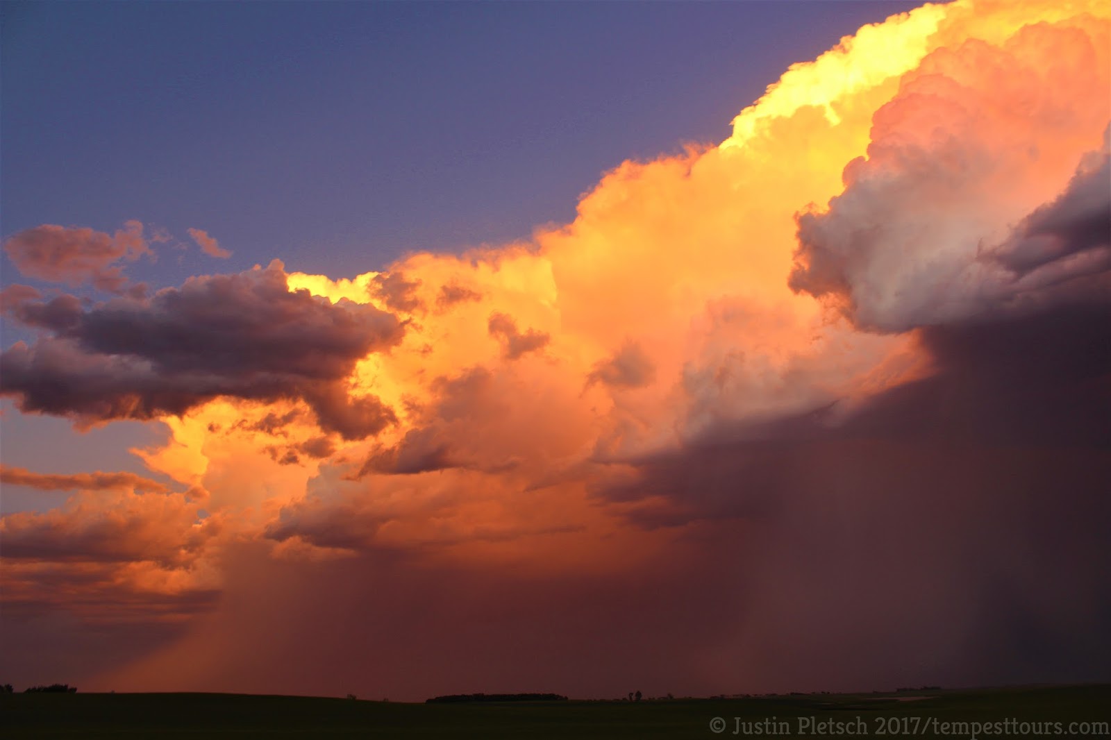
We began the day in Pierre, SD, and we were on the road by 8:30 a.m.  The models were fairly consistent with three key areas of development later in the day.  The first area was near the Manitoba/ND border, which was well out of our reach.  Another area was near Minot, ND, where instability and moisture were excellent.  The final area was closer to the NE/SD border, which did not look as promising.  After our morning briefing, we headed north towards Bismarck, ND on US 83.  Lunch was a fast food stop in Steele, ND, and we continued north on Hwy 3 towards Harvey, ND.  We found a convenience store in Harvey, and hoards of other chasers were there, too.  It was hard not to judge them with all of their fancy instruments prominently displayed outside their vehicles.  Luckily for us, we had Bill, who uses his experience and instincts to get us on the best storms.  Anyway, we decided to head to the northwest on US 52 out of Harvey, and we stopped in Martin, ND for a brief time.  We continued northwest, and we explored the town of Balfour, ND, where there was an old church and an old school.  Storms were beginning to develop to our southeast, so we headed back to Anamoose, ND, where we did some more "power waiting."  After we decided that the better storms would be a bit further south, we returned to the town of Harvey and headed south on Hwy 3.  We found a spot to watch the developing storm, and it began splitting.  After this occurred, the right-moving storm became the dominant cell, and it quickly exploded to 50,000 feet.  We knew this would be a beast, so we latched onto it.  As we continued south on Hwy 3, it continued to look amazing on radar, and it also looked great in person.  When we got to Hwy 200, we blasted west to get a better look at the base.  Due to the high lightning danger, we could not stay in one spot for long, especially with how frequently lightning was seen.  At this point, the storm was starting to move due east, which was a sign that it was rotating.  We needed to drop south on Hwy 3, so we could stay in front of the action area and steer clear of the large hail (3+ inches).  Along the way, we stopped so we could see what was happening.  The storm came VERY close to producing a tornado multiple times, and it was exciting to see the turbulent motion underneath the base.  When we arrived in Tuttle, ND, we headed east on Hwy 36 towards Woodworth, ND.  At this point, the storm was beginning to get messy, so we continued into Pingree, ND, where we found a bar to use as a pit stop.  We headed north on US 52 to Hwy 9, where we headed east and followed the storm into Courtenay, ND.  As the storm continued its eastward trek, we stopped outside of town to watch it.  We saw what appeared to be a tornado, but it was behind a rain shaft, so we wrote it off as a shadow.  When reports started coming in of a tornado on the ground, we were more confident that what we saw was, indeed, a tornado.  The setting sun and frequent lightning provided a nice end to the long day of chasing.  We drove 619 miles and ended up in Bismarck, ND for the night.
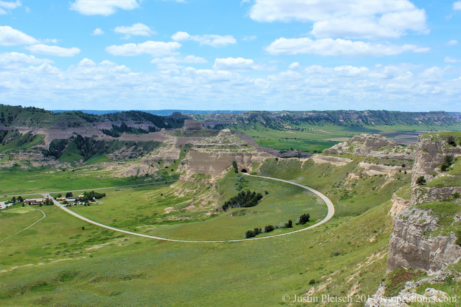
Wednesday, June 21, 2017

June 8 atmospheric cap that wouldn't budge


Look at that beast!
Mid-level funnel near Edgemont, SD
We began the day in Gering, NE, and our plan was to get up near Valentine, NE.  Model trends were showing some beefy storms firing along the SD/NE border and diving towards the southeast.  We also knew that we wanted to be closer to N Central ND for tomorrow's severe weather prospects.  In any case, we left Gering and headed north on Hwy 29. We enjoyed lunch at the Longhorn Saloon Bar and Grill in Harrison, NE.  After lunch, we continued our drive east on US 20 after lunch and arrived in Valentine a few hours later.  Our vans needed fuel, so we stopped and gave the guests a chance to stock up on some goodies before heading north on US 83 out of Valentine.  We drove to Mission, SD, and we stopped a few miles out of town to monitor the weather.  Any towers that we saw were quickly suppressed by the atmospheric cap that would not budge.  The biggest reason why storms were unable to develop was due to a lack of convergence and no southerly winds to help create storms.  In the end, this was a blessing in disguise, because we ended up in Pierre, SD for the night.  If storms would have started going up, we would have chased them south.  This would mean a much longer drive for tomorrow and an earlier start.  We drove 391 miles today.
Core with hail larger than 1"

*Note*  I did not take any pictures today, so I will post more from the Edgemont day on June 7.

Thursday, June 15, 2017

June 7 supercell from Edgemont, SD to Henry, NE

Guernsey State Park
Storms near Rapid City, SD
We found ourselves in Guernsey, WY to start the day, and we were in pretty good position for the day's severe weather prospects.  Models were consistent with a long-lived supercell from SD to NE.  After the weather briefing, we drove through Guernsey State Park on our way to Lusk, WY.  It was a beautiful drive, and we stopped once to take pictures.  When we arrived in Lusk, we ate at The Pizza Place, which has been around since 1996.  The food was decent, and the longer lunch actually worked in our favor.  Bill was wanting to drive up to Rapid City, SD, where models were wanting to initiate thunderstorms.  Along the way, we stopped in Edgemont, SD for a pit/fuel stop, and we noticed a cell a few miles away.  Bill liked the look of this storm, and it was isolated from the activity near Rapid City.  We decided to hedge our bets with this cell, and we definitely were not disappointed!  As we were driving south on US 18/85, we drove into the storm in order to see how large the hail was.  At that time, the hail was about an inch in diameter, which was enough for the storm to become severe warned.  Because of its slow, southward movement, we were able to stay in front of it very easily.  As we got closer to Lusk, there was more development to the east, which was also moving slowly.  We took US 20 east out of Lusk, as this road would be our best bet to watch the Edgemont cell and monitor the new activity.  The Edgemont cell became a beast, and it ingested any storms in its path.  As we continued to chase it, the cell showed signs that it would drop a tornado, but it kept getting undercut by its own outflow, which is rain-cooled air from the storm.  As we got south of Harrison, NE, the storm showed awesome structure, and it kept going through different phases.  At one point it would have a pseudo-shelf cloud, and then it would develop a nice, rotating wall cloud, and then back again.  I guess you could say the storm had a bit of an identity crisis, because it did not know what it wanted to to.  In either case, it kept ingesting storms in its way, and it gave us a good show all the way to Henry, NE, when it substantially weakened.  We were on this storm for 5+ hours, and we were certainly not disappointed, especially since the previous two days were not that great.  After driving 341 miles, we stayed overnight in Gering, NE.
Our storm as an "infant"
Our storm as a "teenager"


Our storm as an "adult"

Monday, June 12, 2017

June 6 the storms that couldn't


Scottsbluff National Monument
Weak storm near Wheatland, WY
Today, we began in Alliance, NE, and we were in good position for the day's festivities.  After the morning weather briefing, we headed into Scottsbluff, NE for a Walmart run and lunch.  Bill found a place called The Shed, and we were the only patrons there.  The staff was more than happy to accommodate us, and the food was decent.  After lunch, we toured the Scottsbluff National Monument, and the scenes were breathtaking.  It was interesting to read about its history on the Oregon Trail, and the walkways provided cool views of the area.  We left after about a half hour, and we headed into LaGrange, WY to fuel the vans.  Unfortunately, there was not a gas station, so we drove to Cheyenne, WY, where we fueled the vans.  Storms began firing up near Wheatland, WY, so we began driving north to investigate these cells.  They were not looking very healthy, but there was another cell to our southwest that was ramping up fast.  The only downside was that it was in the Laramie Mountains, and it was moving to the southwest, away from us.  Plus, the road network was very sparse, but we attempted to go after it.  After driving on WY 487 for about 40 minutes, the storm looked anemic, so we headed back to I-25 and drove towards Chugwater to investigate new development.  This was the final straw, as those storms also began fizzling, which was the story of the day.  The lack of wind shear was the main culprit, but we at least got a decent sunset out of the day.  We drove 422 miles and stayed overnight in Guernsey, WY.

June 5 storms near Chugwater, WY and Lusk, WY


East of Chugwater, WY
North of Lusk, WY
We began the day in Denver after driving 347 miles the previous day.  After meeting the guests and giving them the orientation, we headed north towards our target area of Lusk, WY.  Despite the pitiful weather pattern, Bill was confident that we would get a strong storm or two near the target area.  After a quick lunch stop in Wellington, CO, we continued north to Chugwater, WY.  We decided to head east to investigate a cell that was looking healthy.  It exhibited signs of rotation, and the radar indicated some strong rotation within the storm.  As we pulled off the road to watch it, a friendly dog came up and tried to get in the vans.  We felt bad as we drove off to stay ahead of the storm, but that's life.  Anyway, our storm eventually fizzled, but there was new development to our north near Rapid City, SD.  We headed north into Torrington, WY, where we had another pit stop, and then we blasted north.  As we approached Lusk, Bill decided to head north out of town and find a good vantage point.  He found rooms for us in Alliance, NE, so he was not too gung-ho about going too far north.  We waited around for about 30 minutes, and then we headed back into Lusk for another pit stop.  After the pit stop, we drove east on US 20 toward Chadron, NE, where we watched the lightning for a bit.  We turned on Deadhorse Road, and we figured we would not have to worry about cars.  As it turned out, it was a well-traveled road.  We packed up and drove south out of Chadron and found another place to pull over.  Not only was the lightning better, there were also no cars to worry about!!  In the end, it was an exciting start to the tour, and we drove 435 miles.

Monday, June 5, 2017

It's that time of year again...

Good evening!  It has been a hot second since I last posted, but I will not keep you in suspense any longer.  I began my storm chasing vacation today, and the day's task was simple.  With Bill Reid and Kim George (Guest Relations Manager for Tempest Tours), we began driving the vans to Denver for the start of Tour 5, which begins Monday, June 5.  We left Oklahoma City around 2:30 p.m. after enjoying lunch, and we took the scenic route through Geary, Watonga, Seiling, Woodward, and Fort Supply (all in OK).  As we approached Liberal, KS, we noticed a nice storm base developing to the north.  This was unexpected, given the poor set up for severe weather.  As we approached the storm, the base started looking worse, so we continued on our merry way towards Hugoton, KS.  Luckily, another storm was showing signs that it wanted to do something, and the base had a nice lowering.  There was no visible rotation, and we were too far from the nearest radar to get a good look at the storm.  We pulled over to get a better look at the storm, and we decided to head south towards Hooker, OK, and get ahead of the storm.  It was moving to the SW at a blistering 15 mph.  Staying ahead of it was not a problem, and it continued to look better as we drove.  At one point, there was a clear slot, and we were getting atomized rain.  (Note:  atomized rain can be best described as going through the spot-free rinse cycle in a car wash.  When this type of rain is seen from a storm, it usually means that it is rotating hard.)  Sadly, the storm started weakening as we approached Hooker, because it was competing with other storms nearby for the available energy.  We turned around and found a spot to pull off, after escaping the torrential rain, and watched the storm move away.  The setting sun and double rainbow help bring out the mammatus clouds.  After driving 344 miles, Kim found rooms for us in Hugoton.


Saturday, June 3, 2017

June 11 MT/ND storms

We began today in Billings, MT, and we lost 3 of our guests.  There was a decent risk of severe weather along the MT/ND border, and these guests needed to be back in Denver by Sunday afternoon.  Chris ran them to the airport in the morning and dropped them off at a rental car company.  It was sad seeing them leave, but we understood.  That being said, we hit the road around 8:30, and our plan was to drive a couple hours east.  We ate lunch in Miles City, MT, at a place called Blackiron Grill and Rotisserie.  The food was quite tasty, and the service was very quick.  After lunch, we continued east to Baker, MT, where we found a spot outside of town to wait.  Storms were going up, but they were not moving in the direction we hoped, so we stayed put for a while longer.  The road network was very sparse, so it was crucial that we did not get suckered on a storm too early.  When it seemed like we were going to get skunked, a storm came up that exhibited signs of rotation, and it was moving in the direction we were hoping.  We intercepted the storm about 20 miles east of Miles City along US 12.  It was very picturesque, and the setting sun in the hills provided a very nice backdrop.  As the storm inched closer, lightning became more frequent, and we decided to drive further west.  We decided to abandon the now outflowy storm near Baker, MT, for storms that were near Hettinger, ND.  As we go further away, we noticed the storm we abandoned was showing signs of strengthening.  A reputable chaser reported a brief tornado, so we were rather shocked.  Anyway, the storms near Hettinger looked good on radar, but we quickly found out that they were very junky and not worth chasing.  Eventually, we decided to unsheath the big silver fork and drive to our overnight destination of Belle Fourche, SD for the evening.  Our mileage for the day was 593 miles.