Saturday, October 5, 2013

Joplin, MO EF-5 Tornado

This was an entry I wrote on May 21, 2012 as an intern for WTVO in Rockford, IL.  You can find this entry on the First Warn Weather Team website.
On May 22, 2011, no one knew what was going to happen with the weather.  Early in the morning, all the signs were pointing to a major severe weather outbreak somewhere in the Midwest.  More importantly, everything was primed for an extended tornado outbreak.  An early morning weather balloon launch from the Springfield, MO weather office indicated this as well.
First, let me explain the 4 things SEVERE storms need to develop/survive.  These kind of storms need instability, moisture, lift, and shear.  For instability, there was plenty of CAPE (Convective Available Potential Energy), which is a term for the amount of gasoline in the atmosphere to fuel storms.  Keep in mind that you don't need a whole lot of CAPE for severe storms (or any storms, for that matter) to develop.  Think about a car.  Even if there is just a little bit of gasoline in the tank, you will still be able to start the car and go somewhere.  In addition, the early morning sounding showed a very nice veering profile, which means the winds were turning clockwise with height.  Basically, winds that veer with height allow for storms that develop in that area to obtain rotating updrafts.  This, in turn, provides excellent support for tornado development, because a tornado is simply a violently rotating updraft.  Next, there was plenty of wind shear in this same profile, which would allow the storms that develop in this environment to become tilted.  In other words, this would allow these storms to last for hours, as the updrafts and downdrafts would not be interfering with each other.
On a side note, an updraft is air that is moving upward at a very fast speed.  This aids in storm development, and a downdraft comes from storms that are decaying.  If these two things are interacting with each other in the same place in the storm, the storm will not be able to sustain itself.

Anyway, I have already mentioned two of the four things required for the development of severe storms.  For the third item, we need some kind of lift to get the storms to fire off.  This can come in the form of a front, outflow boundary (from previous storms), dryline, etc.  In this case, there was a powerful cold front that plowed through on this day, and that acted as a lifting mechanism.

Moisture is the final ingredient needed to stroke a severe storm.  To give you an idea of what I am talking about, think of when you watch the weather on TV every night.  The meteorologist will often refer to the dew point and/or humidity.  Both of these are ways to measure moisture, and storms thrive in high moisture environments.
 Now that we have all these ingredients in one place, let's talk severe weather!!!  The big event on May 22, 2011, happened in Joplin, MO.  An EF-5 tornado rolled through and completely destroyed everything in its path.  On the side of this post, I have included some radar images from the event.  The images to the far left are the Radar Reflectivity, and the images to the right are Storm Relative Velocity, which is a measure of wind shear.  From top to bottom, the time stamps are 5:29 PM, 5:43 PM, 5:48 PM, 5:53 PM, and 5:58 PM.  Notice in the third image there is an area enclosed by a white circle labeled "debris."  Well, that is an example of what the radar is detecting, and it is known as a debris ball.  These occur with particularly destructive tornadoes.  Want to know more about this devastating event?  Please take a look at this link for a further synopsis of this event.

The Perils of Storm Chasing

I figure writing an entry about storm chasing and its associated risks/dangers would be appropriate, considering the activity that happened in NE/SD on Friday.  Many people feel they can simply jump into a car and go after storms.  Well, there is much more to that than they think.  Those people, often referred to as "yahoos", do not realize just how dangerous this hobby can be.  Not only do you have to deal with rapidly changing weather, you also have to deal with issues like other chasers, wildlife, terrain, fatigue, poor road networks, and potential vehicle break-downs.  Let me explain.

Obviously, getting up close and personal with nasty weather is the primary issue.  Even if you have high-end equipment to help you predict what will happen, you never know until it actually occurs.  There have been many instances when chasers were caught in the path of monstrous storms, and they were lucky to escape alive.  As an example, our group had the chance to see the El Reno, OK tornado this year.  Shortly after forming, it made a beeline in our direction, so we had to get out of there quickly.  If we would have waited any longer, I would not be here writing this entry.  It is a sobering reminder that we are puny human beings at the mercy of something much bigger than us.

Other storm chasers, and even non-chasers, tend to go bonkers when inclement weather threatens their area.  This means roads get plugged up with excessive traffic, because everyone wants to see what's going on.  The natives are often drawn to chaser traffic, and they become a part of the long lines of cars going down the highway.  Unfortunately, these natives usually do not have the expertise or know-how to be a successful chaser, so they do more harm than good.  The same can be said for some of the "chasers" out there.  There are some chasers who are out for one reason and one reason only: to get the "money shot."  This means they will do anything they can to obtain it, even if it means breaking traffic laws and putting their own lives at risk.  On the other hand, there are those who chase to simply view Mother Nature at her worst (or finest, depending on who you talk to).  This is the category I fall in, because it puts all my knowledge about weather to use.  Being able to see a gigantic supercell up close is an absolutely amazing experience, and just looking at pictures does not really do it any justice.

Wildlife and terrain/poor road networks are also issues storm chasers face.  There have been numerous times during my chasing experiences that we come across livestock that is not confined to a fenced off area.  Fortunately, cows tend to run away if humans take even one step toward them, but we still need to approach them with caution.  They can cause problems when they are in the middle of the road and will not move, so all you can do is sit back and hope they move.  Snakes, fire ants, and other creepy crawlies are also a part of the game.  You need to constantly be mindful of where you are stepping, especially when walking in tall grass.  Fire ant mounds are not always in the shape of a mound, as I have come across some that are completely flat.  Even though I have never been attacked by those things, I hear their bites are quite painful.  Snakes tend to congregate in tall, grassy areas, and rattlesnakes are very common in the Great Plains, which is where the prime chasing territory is.  In 2009, our group came across a rattler while photographing an abandoned house.  It was coiled up and ready to strike, so we made sure to keep our distance.

The terrain and poor road networks are also a couple more hazards chasers must deal with.  As an example, Cherry County in Nebraska has only 3 paved roads, with a few gravel/dirt roads sprinkled in the mix.  You need to be very precise in what roads you choose, because it could determine whether or not you get to see the storm from the angle you want.  On the other hand, Iowa has an excellent road network, so there is more room for error.  Regardless, you do not want to be caught in the path of a monster, even if you are in an area with plenty of roads to choose from.  The terrain can also be an issue, especially if you are chasing in a river valley or in the Sandhills of Nebraska.  River valleys tend to have a lot of trees, which means you will not be able to get a good visual of the storm.  This translates to you being unable to see if a tornado is being produced, so you will literally be chasing blindly.  Likewise, very hilly terrain can be a burden unless you are able to find a good vantage point.  Also, hills tend to cause issues with phone signals, which means you might be without internet for a bit.

Vehicle break-downs and fatigue are the other issues chasers have to endure.  Considering you could end up driving 600+ miles in any given day, your vehicle will need maintenance.  However, even routine maintenance may not be enough, especially if you get caught in storm throwing softballs at you.  If any of your windows break, it is best to call off the chase and get it fixed ASAP.  Likewise, gravel roads can cause flat tires, due to jagged rocks.  Stuff happens, so you need to be prepared for the worst.  However, fatigue is probably the next biggest hazard.  Being on the road for 12+ hours in a day is quite taxing, and you may not get to your hotel until 1 AM.  This is yet another reason why chasing is not for everyone, because your time chasing is usually more than your time sleeping.

Have I completely turned you away from storm chasing?  I hope not!!  When you have a healthy respect for the weather, your chances of surviving are much better.  Always make sure you have a back-up plan, because plan A or plan E might not work.  In a sense, chasing is a lot like playing chess.  One wrong move, and you end up in checkmate.  For those who are interested, there are a couple reputable groups out there, and I am a driver/guide for Tempest Tours.  I will post those links at the bottom of this entry.

Thanks for reading!!!

Tempest Tours (led by William T. Reid, Brian Morganti, and Dr. Bob Conzemius)
Silver Lining Tours (led by Roger Hill and Dr. David Gold)
College of DuPage (although I do not personally endorse them, they are led by Victor Gensini, Paul Sirvatka, and Dr. Walker Ashley, who are all very great at what they do)

Wednesday, August 21, 2013

May 31 El Reno, OK Tornado

Cyril, OK
We spent the night in Ardmore, OK, as we knew we would be in excellent position for today's chase.  Upon waking up in the very run down Days Inn, we sensed that today was going to be very special.  I woke up around 8:00 that morning, and the dew points were already in the 70s.  During the weather briefing, CAPE values were progged to be in excess of 4500 J/kg, which means an incredibly unstable atmosphere.  Temperatures were predicted to be in the mid 90s, which would be more than enough to break any cap the atmosphere would have.  Finally, lift would not be a problem, as we were targeting what is known as the "triple point", which is the point where the dryline, warm front, and cold front meet.  This is often the hotspot for severe activity.  Unfortunately, we were concerned that the cap may not be strong enough to hold in all the necessary ingredients, so early initiation was not out of the question.
Chris Gullickson by the van, with guests
scattered throughout the park

After the briefing, we heading into downtown Ardmore for a late breakfast/early lunch at a place called The Hamburger Inn.  We took our time, because we were already in good position.  Once we finished, we drove for about 2 hours to the west to a town called Waurika, OK, where we found a convenience store.  One of our guests sat on a bench, and there was a black widow spider underneath it.  In my experience as a chaser, I have had very good luck on days that I see a poisonous creature.  For example, on the day of the Goshen County tornado in 2009, we came across a rattlesnake.  Anyway, we eventually made our way to Cyril, OK, where we found a park to relax for a bit.  We also figured this would be a good time to get a group picture.  Even at this point, nothing was starting to go up, which meant the cap was still holding its own.

Waiting for initiation
near Minco, OK
We continued north into Central Oklahoma, where CAPE values were near 5500 J/kg.  This was absolutely phenomenal, as any storm that could break through the cap here would become a beast.  There were some Cu that were trying to do something, but they sputtered.  After making what would be our final pit stop for the day in Minco, OK, we headed a few miles west to look for a nice open area to observe the now towering Cu.  There were some decent looking cells to the west, but we did not want to go after a sucker storm and miss the big show later.  At last, there was an even better cell that just developed, and it looked promising, so we drove in that direction.

Wall cloud
As we continued west, those little cells from about 15 minutes ago were now explosive updrafts.  This is what we were waiting for!!!  Large hail was also falling from these storms, so it was amazing how fast this all transpired.  In a case like this, targeting the southern-most storm would be our best option.  It had a nice rain-free base, which is where a wall cloud would form.  We were about 9 miles east of this storm, and it was moving right for us, so we played the waiting game.  Little did we know how much our patience would pay off.


Scraggly wall cloud
At this point, the cloud tops were at least 60,000 feet, which does not happen a whole lot.  We had a nice vantage point of a scraggly wall cloud, so we were in good shape to watch a tornado, if one was going to form.  As we were taking pictures, we were getting hail and moderate rain, so we repositioned ourselves to the SE of the storm.  After heading east for about 5 miles, we found a very good N-S paved road, and the terrain was very flat and had no trees.  Basically, this was a chaser's dream landscape, as it would provide an amazing view of the storm.  We stopped about 3 miles west of the El Reno airport, and we noticed the supercell was becoming an HP monster.  This was not good, as if a tornado did form, it would be hidden in that dark curtain of nastiness.  There was a storm base to our NW that had an earlier tornado report, and that storm base was now starting to act weird.  Around 5:54 PM, it appeared that a funnel cloud was trying to develop, and rotation was becoming more evident.

6:03:19 PM
6:03:26 PM


6:03:45 PM


6:05:18 PM

6:06:00 PM
6:04:37 PM
This is an excerpt from Bill Reid's blog of that day.  "By 6:00 p.m., the nearby storm base on the leading edge of this supercell was changing fast.  VERY FAST.  VERY VERY VERY VERY FAST!!!  There is some lowering of the base and some noticeable rotation now.  Is this a tornado hand-off?  Is this a new meso that is quickly cycling up?  Is this west wind that is getting stronger here an RFD wind?  The answers are all YES —- in a matter of two or three minutes, we were suddenly looking at a tremendous and large low-level circulation, just a mile or two to our north-northwest!  This thing formed crazy fast, and it didn’t tease us long before going tornadic.  Big fat funnels and big skinny funnels went up and down and appeared and disappeared beneath this merry-go-round wall cloud.  It was mesmerizing.  It was close!  I held the 5D as steadily as I could as it rolled in HD video mode.  The scene was surreal.  Above the green, grassy countryside these gray/white tornadoes were dancing around beneath the whitish wall cloud, and then around and below this tremendous “mother” funnel cloud.  It was multi-vortex city.  Rain and wind was hitting us hard from the west now.  Were there any other issues?  Yes.  The mother funnel cloud was coming right at us.  UGH."
6:06:40 PM

6:06:43 PM

Basically, we were right in the path of the tornado-cyclone, and we had to get out of there fast!!!  All of a sudden, we were caught in incredibly powerful winds, and we were in the circulation.  We could only go 55 mph, as the roads were made of gravel.  The tornado was speeding along at 45 mph, so there was absolutely no room for error.  Until we were able to get on a paved road, we were at the mercy of the storm.  We were all fortunate to get out alive after our very close brush with death.  Meanwhile, the tornado grew to an astonishing 2.6 miles wide, and wind speeds were estimated at 295 mph.  The size alone made this a record breaker, so it was pretty neat!!  Unfortunately, the weather community lost 3 well respected chasers on this day.
This was the tornado at its peak intensity


6:27:10 PM


As my group made our way into Oklahoma City for the night, we saw just how destructive these storms were.  Eventually, storms started training along the same path, and OKC saw about 8 inches of rain that night.  The damage was unbelievable, and we were lucky to find a hotel that still had power and very little damage, even though the hotel itself was a dump.  When I woke up the next morning, I realized that what had happened was not a dream.  It was a very sobering reminder that storm chasing is very dangerous activity, and even the best chasers out there will find themselves in dangerous situations.  We were incredibly lucky to escape with no damage to our equipment or guests and even happier we got out alive.  The experience exponentially increased my respect for the weather.

For those who are interested, you can visit Bill Reid's Stormbruiser blog at this link.

Monday, July 29, 2013

Haxtun, CO Supercell

On May 28, we started the day in Salina, KS.  If we would have had the ability to tell the future, we could have stayed there all day and see an EF-4 tornado tear through not too far from there.  Alas, part of the fun of storm chasing is not knowing what is going to happen.  During the morning's weather briefing, we decided to head NW toward the CO/NE border.  Not only would we be in position for the next day, but it appeared that discreet supercells would be more favorable in that vicinity.  For those who are not familiar with weather jargon, a discreet supercell is an ideal chase target, because it has no other neighboring storms to compete with for the available ingredients (moisture, instability, shear, lift).  In other words, a discreet supercell is a greedy storm, and storm chasers LOVE greedy storms!!!

Getting back on track, we stopped for lunch in Hays, KS, at a neat little sandwich cafe.  After eating and analyzing the current data, we continued on our current course.  As we got near Burlington, CO, a perky Cumulus (Cu) field was starting to show up on the visible satellite.  When a chaser sees this, he starts getting more excited, because it shows the atmosphere is starting to become more unstable.  Our tour leader, Bill Reid, chose to head north out of Burlington on U.S. 385.  We drove through scenic Yuma county and saw the flat part of  CO that not many people know about (ie. no mountains!!!).  Eventually, we intercepted a rather interesting cell near Haxtun, CO, and it started forming a "bowl" shaped base.  This was a sign that the storm was getting more organized, and it would eventually begin rotating, turning into an absolutely beautiful supercell.  As we drifted north towards Julesburg, CO, it took on a mothership appearance.  We were also fortunate to witness an event known as "alternating vorticies", which was simply 2 vorticies spinning around each other in the cloud.  As we followed the storm out of Julesburg and headed east to stay ahead of it, we began experiencing some golf ball sized hail and frequent lightning.  Once we were a good distance in front of the cell, we stopped multiple times to take pictures.  As the sun began to set, the storm grew weaker, but still maintained its structure until the very end.  Our total mileage for today was 513 miles, and we found rooms in Ogallala, NE.

Haxtun, CO

Julesburg, CO

Julesburg, CO

Julesburg, CO

Julesburg, CO

Julesburg, CO

Wednesday, July 24, 2013

TX/OK Panhandle LP Supercell

After much consideration, I will be going back to school full-time in the spring to pursue my degree in Elementary Education.  This has always been in the back of my head since earning my Meteorology degree, but money was the biggest issue.  I feel like I am being called to teach, so this will be interesting to see where this goes.  Before I can even apply to the program, though, I will need to take/pass 12 classes as well as pass the Basic Skills Exam (aka the TAP).  If all goes according to plan, I will be starting my first Professional semester in Fall 2015, with my final semester being Spring 2017.  Wish me luck!!

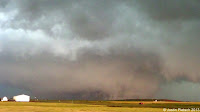
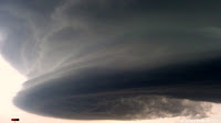
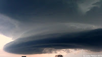
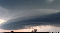
On another note, I wanted to share some more storm chasing pictures with everyone.  These ones are from June 3, and they were taken near the TX/OK border in the Panhandle region.  This day marked the start of my second trip with Tempest Tours, and we began our journey in Denver.  After our group introduction/orientation/weather briefing, our initial target would be in Liberal, KS.  Yes, that would mean a long drive, but our tour director, Dr. Bob Conzemius, kept confidence that we would make it in time to possibly see a storm.  Initially, it appeared early convection was going to screw everything up, but that would not be the case.  Upon arriving in Liberal, we continued to drift south towards Perryton, TX, when we were treated to this nifty display:

 Notice the smoke in the picture.  This is a great illustration of what a storm's inflow does.  In laymen's terms, inflow is the air flowing into the storm.  In this case, we were experiencing warm/moist air, which is one of the necessary ingredients for storm development.  We had to keep moving to avoid getting sandblasted by the storm's outflow, which is air flowing OUT of the storm.  As time progressed, we were fortunate enough to see some supercellular structure and a rainbow (last 3 pictures near the bottom.  All in all, this was a great way to start my second week storm chasing, and I could not have been happier.  We drove 458 miles on this day.


Sunday, July 21, 2013

Pilot Entry

Hello everyone!  This is my first time in the blogging community as an active blogger.  I will be talking about anything and everything on my page, but I will also take suggestions.  Anyway, I grew up in Prophetstown, IL, which is about an hour east of the Quad Cities.  I saw my first tornado when I was 7, and it was a couple miles away from our house in the country.  It was a textbook rope tornado, and it just stayed in corn fields.  Even though it did not last very long, it was still pretty neat to see it take shape.  I guess you could say that is what sparked my interest in Meteorology, and in 2011, I graduated from NIU with my degree.  Now, I am in the job hunt, along with thousands of other graduates.  Currently, I am employed with Veolia and Rockford Charter Coach, and I drive buses for both.  During the summer months, I usually try to get out and do some storm chasing, and I was fortunate enough to get paid to storm chase last year and this year.  Not too shabby!!  Here are a couple pictures from this year's festivities.  These were taken near Santa Rosa, NM, on June 7 around between 9:15 PM and 9:30 PM.