Monday, July 29, 2013

Haxtun, CO Supercell

On May 28, we started the day in Salina, KS.  If we would have had the ability to tell the future, we could have stayed there all day and see an EF-4 tornado tear through not too far from there.  Alas, part of the fun of storm chasing is not knowing what is going to happen.  During the morning's weather briefing, we decided to head NW toward the CO/NE border.  Not only would we be in position for the next day, but it appeared that discreet supercells would be more favorable in that vicinity.  For those who are not familiar with weather jargon, a discreet supercell is an ideal chase target, because it has no other neighboring storms to compete with for the available ingredients (moisture, instability, shear, lift).  In other words, a discreet supercell is a greedy storm, and storm chasers LOVE greedy storms!!!

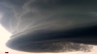
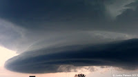
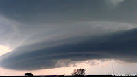
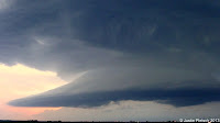
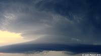
Getting back on track, we stopped for lunch in Hays, KS, at a neat little sandwich cafe.  After eating and analyzing the current data, we continued on our current course.  As we got near Burlington, CO, a perky Cumulus (Cu) field was starting to show up on the visible satellite.  When a chaser sees this, he starts getting more excited, because it shows the atmosphere is starting to become more unstable.  Our tour leader, Bill Reid, chose to head north out of Burlington on U.S. 385.  We drove through scenic Yuma county and saw the flat part of  CO that not many people know about (ie. no mountains!!!).  Eventually, we intercepted a rather interesting cell near Haxtun, CO, and it started forming a "bowl" shaped base.  This was a sign that the storm was getting more organized, and it would eventually begin rotating, turning into an absolutely beautiful supercell.  As we drifted north towards Julesburg, CO, it took on a mothership appearance.  We were also fortunate to witness an event known as "alternating vorticies", which was simply 2 vorticies spinning around each other in the cloud.  As we followed the storm out of Julesburg and headed east to stay ahead of it, we began experiencing some golf ball sized hail and frequent lightning.  Once we were a good distance in front of the cell, we stopped multiple times to take pictures.  As the sun began to set, the storm grew weaker, but still maintained its structure until the very end.  Our total mileage for today was 513 miles, and we found rooms in Ogallala, NE.

Haxtun, CO

Julesburg, CO

Julesburg, CO

Julesburg, CO

Julesburg, CO

Julesburg, CO

Wednesday, July 24, 2013

TX/OK Panhandle LP Supercell

After much consideration, I will be going back to school full-time in the spring to pursue my degree in Elementary Education.  This has always been in the back of my head since earning my Meteorology degree, but money was the biggest issue.  I feel like I am being called to teach, so this will be interesting to see where this goes.  Before I can even apply to the program, though, I will need to take/pass 12 classes as well as pass the Basic Skills Exam (aka the TAP).  If all goes according to plan, I will be starting my first Professional semester in Fall 2015, with my final semester being Spring 2017.  Wish me luck!!

On another note, I wanted to share some more storm chasing pictures with everyone.  These ones are from June 3, and they were taken near the TX/OK border in the Panhandle region.  This day marked the start of my second trip with Tempest Tours, and we began our journey in Denver.  After our group introduction/orientation/weather briefing, our initial target would be in Liberal, KS.  Yes, that would mean a long drive, but our tour director, Dr. Bob Conzemius, kept confidence that we would make it in time to possibly see a storm.  Initially, it appeared early convection was going to screw everything up, but that would not be the case.  Upon arriving in Liberal, we continued to drift south towards Perryton, TX, when we were treated to this nifty display:

 Notice the smoke in the picture.  This is a great illustration of what a storm's inflow does.  In laymen's terms, inflow is the air flowing into the storm.  In this case, we were experiencing warm/moist air, which is one of the necessary ingredients for storm development.  We had to keep moving to avoid getting sandblasted by the storm's outflow, which is air flowing OUT of the storm.  As time progressed, we were fortunate enough to see some supercellular structure and a rainbow (last 3 pictures near the bottom.  All in all, this was a great way to start my second week storm chasing, and I could not have been happier.  We drove 458 miles on this day.


Sunday, July 21, 2013

Pilot Entry

Hello everyone!  This is my first time in the blogging community as an active blogger.  I will be talking about anything and everything on my page, but I will also take suggestions.  Anyway, I grew up in Prophetstown, IL, which is about an hour east of the Quad Cities.  I saw my first tornado when I was 7, and it was a couple miles away from our house in the country.  It was a textbook rope tornado, and it just stayed in corn fields.  Even though it did not last very long, it was still pretty neat to see it take shape.  I guess you could say that is what sparked my interest in Meteorology, and in 2011, I graduated from NIU with my degree.  Now, I am in the job hunt, along with thousands of other graduates.  Currently, I am employed with Veolia and Rockford Charter Coach, and I drive buses for both.  During the summer months, I usually try to get out and do some storm chasing, and I was fortunate enough to get paid to storm chase last year and this year.  Not too shabby!!  Here are a couple pictures from this year's festivities.  These were taken near Santa Rosa, NM, on June 7 around between 9:15 PM and 9:30 PM.